|
To contact us: |

|
Germania- Albaniana, NL |
|
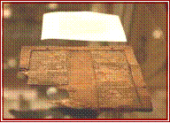
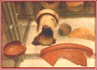
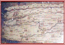
The Peutinger map, a medieval reproduction of a Roman roadmap from the fifth century. The map shows roads, rivers, towns and fortresses in a very abstract manner. Reproduction Archeon in Alphen aan den Rijn. (author’s photo). Local and imported fine quality pottery (40 – 270 AD) & wax tablet (photo: Wil Kokelaar) |


|
Target Britannia – Recent Work At Fort Albaniana, Germania Inferior
By Eveline J. Verhoeve
The northern frontier of the Roman Empire, the Limes, stretches from Britain to the Black Sea following the old prehistoric trading route, incorporating the river Rhine in the Roman province Germania Inferior. Protecting the frontier was a chain of fortresses, until recently the oldest forts in the western part of the province were believed to have been built from 47 AD when general Corbvlo was ordered to guard the river Rhine as the new frontier. New excavation results from the Albaniana fortress in modern Alphen aan den Rijn, Netherlands, are demonstrating that the first fortresses were constructed as early as the year 40 AD on the orders of the Emperor Caligula. What would Caligula gain from building a fortress along a river in a swamp in an area that was well managed already by one of his generals? Corbvlo was doing a fine job in pacifying the tribe of the Fries and organizing the northern part of Germania Inferior. The answer lies in the planning the long awaited invasion of Britain, with Caligula casting himself as another Julius Caesar. The river Rhine was to be deployed for logistic support during the invasion of Britain. Caligula’s transportation route followed along the rivers Rhône, Saône and Rhine, and the fort at Albaniana, the fortresses at Valkenburg and Fectio were constructed not to protect the Limes but to support an early invasion of Britain. The dating of the building of the Roman fortresses on the northern frontier in Germania Inferior is usually taken as beginning in the year 47 AD. That was the year the Roman emperor Claudius ordered his general Corbvlo to retreat from Friesland, which he was organizing as a new Roman province, and to guard the river Rhine as the new frontier instead. Most excavation substantiates this point of view. However a date for Valkenburg has been suggested to between 39-41 AD, though the evidence is circumstantial. Valkenburg’s plan is unusual, deviating from the standard ‘playing card’ layout. Without further excavation evidence though it has been difficult to accurately explain why this early outpost existed and why it looked different. |